Tampilkan postingan dengan label Archaeology. Tampilkan semua postingan

Guatemala reveals treasures from underwater Mayan ruins

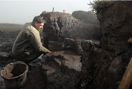
Archaeologists in Guatemala have retrieved artifacts from ancient Mayan ruins submerged in picturesque Lake Atitlan that officials estimate could be more than 2,000 years old. 


Scuba divers exploring the underwater ceremonial site of Samabaj found the remarkable pottery pieces intact and with detail of carvings and color still evident despite the artifacts spending thousands of years at the bottom of Latin America's deepest lake. 

"We have found pieces in Samabaj dating back 200, 300 B.C. to 300 A.D. of different types such as incense burners that are 1.5 meters tall with four incredible cardinal points," commented Rosendo Morales, Exhibition Coordinator of the Museo Lacustre Lago De Atitlan. 

 "We are still asking questions about how these items could have been preserved for 2000 - 2200 years in the lake until now and still retain a texture that you can appreciate.” 

Now, the pottery pieces are housed at Museo Lacustre Lago de Atitlan. 


Researchers believe the artifacts were housed on an island until a catastrophic event, like a volcanic eruption or landslide, raised water levels and drowned out the ancient site of Samabaj. 

With investigations still taking place, the exact location of the site is a closely guarded secret, since archaeologists want to protect it from looters who fish in the ruins for artifacts to be sold, sometimes for thousands of dollars, on the black market. 

Once complete tourist officials hope to open Samabaj to curious international visitors. 

Source: NTD Television [November 19, 2011]

More on Oldest rock art in Egypt discovered

Using a new technology known as optically stimulated luminescence (OSL), a team of Belgian scientists and Professor John Coleman Darnell of Yale have determined that Egyptian petroglyphs found at the east bank of the Nile are about 15,000 years old, making them the oldest rock art in Egypt and possibly the earliest known graphic record in North Africa. 

Belgian archaeologist Wouter Claes poses with a panel with wild bovids (Bos primigenius or aurochs) at the Qurta II site [© RMAH, Brussels/Yale University]
The dating results will be published in the December issue of Antiquity (Vol. 85 Issue 330, pp. 1184–1193). The site of the rock art panels is near the modern village of Qurta, about 40km south of the Upper-Egyptian town of Edfu. First seen by Canadian archaeologists in the early 1960s, they were subsequently forgotten and relocated by the Belgian mission in 2005. The rediscovery was announced in the Project Gallery of Antiquity in 2007.

Wooden scaffolding constructed in March 2008 to reach the rock art at the Qurta I site. The Nubian sandstone scarp to the left of this location has been quarried away [© RMAH, Brussels/Yale University]
Wooden scaffolding constructed in February 2007 to allow access to the rock art at the Qurta I site. The northern edge of the Kom Ombo Plain with the village of Qurta is in the background. The Nile runs right behind the large hill in the far distance [© RMAH, Brussels/Yale University]

The rock art at Qurta is characterized by hammered and incised naturalistic-style images of aurochs and other wild animals. On the basis of their intrinsic characteristics (subject matter, technique, and style), their patina and degree of weathering, as well as the archaeological and geomorphological context, these petroglyphs have been attributed to the late Pleistocene era, specifically to the late Palaeolithic period (roughly 23,000 to 11,000 ago). This makes them more or less contemporary with European art from the last Ice Age — such as the wall-paintings of Lascaux and Altamira caves. 

Detail of the main rock art panel at the Qurta I site, showing how the makers of the rock art used the relief of the rock surface to lend volume and movement to the animal images [© RMAH, Brussels/Yale University]
Detail of the main rock art panel at the Qurta I site, showing several wild bovids (Bos primigenius or aurochs) and a stylized human figure with outstretched arms (center below) [© RMAH, Brussels/Yale University]
“The palaeolithic rock art at Qurta reveals that the well-known cave art of the late Pleistocene in Europe was not an isolated phenomenon. Qurta puts North Africa firmly in the world of the earliest surviving artistic tradition, and shows that tradition to have been geographically more wide-spread than heretofore imagined,” commented Darnell, professor of Egyptology. The authors of the study note that while archaeologists generally did not dispute the estimated age of the images, proof in the form of indirect or direct science-based dating had hitherto been lacking. 

American archaeologist Elyssa Figari recording rock art at the Qurta I site. The panel contains 33 images, including 25 wild bovids and a stylized human figure [© RMAH, Brussels/Yale University]
In 2008, an interdisciplinary team of scientists directed by Dirk Huyge of the Royal Museums of Art and History in Brussels (Belgium) discovered partly buried rock art panels at one of the Qurta sites. The deposits covering the rock art, in part composed of wind-blown sediments, were dated at the Laboratory of Mineralogy and Petrology (Luminescence Research Group) of Ghent University (Belgium) using OSL dating. This technology can determine the time that has elapsed since the buried sediment grains were last exposed to sunlight and offers a direct means for establishing the time of sediment deposition and accumulation. Based on analysis provided through this method, it was determined that the petroglyphs at Qurta are at least 15,000 years old. This is the first solid evidence that the rock art dates from the Pleistocene age, making it the oldest graphic activity ever recorded in Egypt and the whole of North Africa. 

The Qurta I site is situated along a small canal. The scaffolding high up the hillslope indicates the location of the main rock art panel [© RMAH, Brussels/Yale University]
The fieldwork for this study was funded by the William K. and Marilyn M. Simpson Endowment for Egyptology of the Yale Department of Near Eastern Languages and Civilizations. The laboratory analyses were supported by the Fund for Scientific Research – Flanders. In addition, the Netherlands-Flemish Institute in Cairo and Vodafone Egypt offered administrative and logistical support 

Author: Dorie Baker | Source: Yale University [November 10, 2011]

Cirencester Roman dig is 'history changing'

Excavations in Cirencester have unearthed one of the earliest burial sites ever found in Roman Britain. 

Archaeologists have uncovered more than 40 burials at the site [Credit: BBC]
The dig at the former Bridges Garage on Tetbury Road has uncovered over 40 burials and four cremations. 

Experts say it is the largest archaeological find in the town since the 1970s. 

Neil Holbrook, chief executive at Cotswold Archaeology, said he could not "underestimate the potential significance" of the discovery. 

Archaeologists said they were particularly excited by the discovery of a child's grave containing a pottery flagon, which could date to the early Roman period, between 70 AD and 120 AD. 

They said if the burial could be dated to this time, it could "challenge the current belief amongst archaeologists" that inhumation burials were not common practice until the later Roman period. 

"Whilst we are being cautious, we can't underestimate the potential significance this discovery could have for archaeologists in Britain," said Mr Holbrook. 

"Our specialists are working hard to provide further information to try to confirm the dating of this site." 

'Amazing so much has survived' 

A dig on the same site, carried out in the 1960s before the construction of the garage, unearthed 46 cremations, six burials and part of an inscribed tombstone dating from the 1st to 3rd Century. 

Project manager for Cotswold Archaeology, Cliff Bateman, said: "It is amazing that so much archaeology has survived the comprehensive building works." 

The former Bridges Garage site lies immediately outside the town, suggesting the burial site complied with Roman law that forbade burial within the town. 

Among items discovered were two bracelets made of green glass beads, jet beads, shale and copper alloy. 

Sonia Gravestock, of St James's Place Wealth Management which owns the site, said: "We were excited to discover that such a significant Roman site was located under our feet." 

The finds will now be conserved, and the skeletons examined at Cotswold Archaeology's head office. 

It is hoped that some of the finds will be put on show to the public in Cirencester's Corinium Museum. 

Source: BBC News Website [November 17, 2011]

Israelis mapping Mount of Olives necropolis

A Jewish group in Jerusalem is using 21st-century technology to map every tombstone in the ancient cemetery on the Mount of Olives, a sprawling, politically sensitive necropolis of 150,000 graves stretching back three millennia. 

A Palestinian worker pushes a donkey loaded with cement bags past the cemetery at the Mt. of Olives in Jerusalem. A Jewish group in Jerusalem is using 21st-century technology to map every tombstone in the ancient cemetery on the Mount of Olives, a sprawling, politically sensitive necropolis of 150,000 graves stretching back three millennia [Credit: AP/Ariel Schalit]
The goal is to photograph every grave, map it digitally, record every name, and make the information available online. That is supposed to allow visitors to find their way in the cemetery, long a bewildering jumble of crumbling gravestones and rubble surrounded by Arab neighborhoods in east Jerusalem. Beset for many years by neglect, it is among the oldest cemeteries in continuous use in the world. 

Around 40,000 graves have been mapped so far by the team, which began work in 2008. They expect to finish recording all of the intact gravestones — an estimated 100,000 in total — by the end of next year. The rest are either so old they are unrecognizable or lie underneath later layers of burial. 

Mappers look at aerial photographs, consult handwritten burial records dating back to the mid-1800s, walk along the rows of graves and dig through piles of dislocated tombstones, noting names and dates. 

"This place has been used for burial since there have been signs of life in Jerusalem," said Moti Shamis, a member of the mapping team. "The cemetery is a mirror of the city — in wartime, we see more graves. When new groups of Jews reach the city, the names on the graves change." 

Like so much in Jerusalem, this project is linked to the city's fraught politics. The mappers are from an organization called Elad, affiliated with the settlement movement, which also works to move Jews into east Jerusalem in an attempt to prevent the city's division in any future peace deal. 

Elad has made it its business to develop sites of Jewish importance in east Jerusalem, reinforcing the Israeli presence in the part of the city the Palestinians want as their capital. 

Jews began burying their dead on the hill that later became known as the Mount of Olives about three millennia ago. It was a convenient site a short walk from the city walls. Over the centuries, burial here became linked to a prophecy in the Book of Zecharia according to which the Messiah would approach Jerusalem from the mount, splitting it in two. Those interred on the hill, this belief posited, would be the first to be resurrected. 

The mount became, and remains, a sought-after place to be buried for Jews in Israel and abroad. 

"As a place of burial it differs from almost every other on earth, in being, as no other is, a witness to a faith that is firm, decided and uncompromising until death," wrote Norman Macleod, a missionary, after a visit in 1864. "It is not therefore the vast multitude who sleep here, but the faith which they held in regard to their Messiah, that makes this spectacle so impressive." 

Member of the mapping team Moti Shamis surveys ancient graves at the Mt. of Olives cemetery in Jerusalem. A Jewish group in Jerusalem is using 21st-century technology to map every tombstone in the ancient cemetery on the Mount of Olives, a sprawling, politically sensitive necropolis of 150,000 graves stretching back three millennia [Credit: AP/Ariel Schalit]
Numerous churches were also built here, associated with events in the life of Jesus. In Christian burial grounds and crypts on and around the mount visitors can find the remains of people like Princess Alice of Battenberg, mother of Prince Phillip of Britain, and Russian Grand Duchess Elizabeth Feodorovna, killed during the Russian Revolution with the rest of the czar's family. 

The project is mapping only the Jewish cemetery, which includes several burial monuments from the time of the second Jewish Temple, about 2,000 years ago. Among the oldest graves that still bear names is one of a medieval scholar, Ovadia of Bartenura, an Italian who came to Jerusalem and died here around 1500. 

The work of the mappers has solved several mysteries, one of them that of the missing grave of Shmuel Ben-Bassat. 

Ben-Bassat was a soldier who died in combat in the war that surrounded Israel's creation in 1948. He was buried on Jan. 14 of that year, before Jewish forces lost the cemetery, along with the rest of east Jerusalem, to the Jordanian army. 

For the next 19 years Jordan controlled the cemetery, paving over part of it to build a road, using gravestones to pave paths in a nearby military camp and abandoning the rest to disrepair. When Israel recaptured the Mount of Olives in 1967, the soldier's family could find no trace of him. 

Going through old burial records as part of the new project, the mapping team discovered a note saying he had been interred "next to Gader Gurjis and in front of Deborah, the widow of Reuven Mirabi." Those graves still existed. Ben-Bassat now has a military gravestone. 

Sometimes the graves recount small tragedies, like that of Joseph Almozig, a Jewish conscript in the Turkish army in World War I who was charged with desertion in 1916. 

Almozig's broken gravestone says he was "executed by hanging at the hands of the Turkish government." Next to him is his mother, Hanina, whose tombstone from more than three decades later notes that to her right lies Joseph, her only son. 

Elsewhere in the cemetery lies Eliezer Ben-Yehuda, the man responsible more than any other for reviving Hebrew as a spoken language, and a national hero in Israel. He was buried here in 1922. Nearby is Menahem Begin, buried in 1992 in a modest grave that makes no mention of the fact that he was Israel's prime minister.

Begin requested burial here, rather than in the country's national cemetery alongside other Israeli leaders, because he wanted to be close to two fighting comrades who killed themselves with grenades moments before they were to be hanged by the British in a Jerusalem prison in 1947. 

Some see the new mapping work in the cemetery as part of what might be termed Jerusalem's "grave wars," by which Israelis and Palestinians use their dead to bolster their claims to the holy city. 

Last year, Israeli authorities accused Israel's Islamic Movement of manufacturing about 300 graves as part of what was supposed to be a restoration of a Muslim cemetery in west Jerusalem. Elsewhere in the same cemetery, an Israeli initiative to build a Museum of Tolerance on land that contained human remains has drawn fierce criticism from Muslims. More recently, Palestinians have sparred with Israeli officials and archaeologists over use of part of a different Muslim cemetery just outside the walls of the Old City. 

"On the Mount of Olives, we have a cemetery that is undoubtedly important to the Jewish people, but we also have a battle over land," said Yonathan Mizrahi, an archaeologist whose group, Emek Shaveh, is critical of much of the Israeli activity in east Jerusalem as heedless of Palestinian residents. 

"The cemetery is identified as Jewish and thus as Israeli and there is an attempt to say — this is a place that needs to be under Israeli control," he said. 

Author: Matti Friedman | Source: Associated Press [November 17, 2011]

Pictish 'seat of power' discovered in Aberdeenshire

An excavation has revealed a fortified early medieval settlement and unearthed significant artefacts which position a tiny Scottish village as a seat of major political power and influence. 

The Craw Stane with possible structures that may represent one or more buildings under excavation in the foreground (scale 2m) [Credit: University of Aberdeen]
Rare Late Roman pottery found during archaeological excavation at the site of a collection of eight unique Pictish symbol stones in Rhynie, has shed new light on this Aberdeenshire village, and provided fresh information on one of Britain’s most mysterious groups of people – the Picts. 

Earlier this year Dr Gordon Noble, from the University of Aberdeen, and Dr Meggen Gondek, from the University of Chester, led the Rhynie Environs Archaeological Project (REAP) in an excavation at the site where carved stones have been found south of the village. 

Between AD400-900 it is understood that the kingdoms of the Picts became some of the most powerful political groups in the north of Britain, but there is very little documented history and archaeological record about these mysterious people. 

The Craw Stane, with Tap O’ Noth hillfort on the left horizon [Credit: University of Aberdeen]
The symbol stones that the Picts left behind are acknowledged to provide a record of their identity, beliefs and lifestyle, although the elaborate carvings on these stones have not been translated and very little direct work has been carried out in relation to these stones, until now. 

The REAP team’s excavation near the Rhynie symbol stones – discovered between the 19th century and the 1970s – is one of the first large scale digs at this kind of site. 

During their excavation the team made some extraordinary discoveries, uncovering burnt material, stone, pottery, metalwork, glass and animal bone within a very substantial system of fortifications at the site. 

Student Joseph Tong excavating the palisade and post setting [Credit: University of Aberdeen]
Dr Gondek said: “Some of the material culture we uncovered is exceptional. This is one of the most significant finds of early medieval imported goods in the north of Britain. 

“The most remarkable were large fragments of a Roman amphora which was originally from the Eastern Mediterranean. This pottery was most likely to be used for transporting or storing wine, or possibly oil.” 

Many of the finds at Rhynie, such the small sherd of glass, which has been identified as a drinking bowl from the 6th or 7th-century AD, or the bronze pins and two amber beads, suggest it was a place of high status associated with fine dining and drinking. 

Amber beads [Credit: University of Aberdeen]
Dr Noble said: “This type of find is exceptionally rare in Britain, and is practically unheard of as far north as this. The type of artefacts we uncovered in Rhynie have only been found in more kingly centres such as Tintangel in Cornwall and Cadbury Castle in Somerset. The nearest site of similar importance in Scotland is Dumbarton Rock, an early royal site of the Britons of western Scotland, which is almost 200 miles away. 

“This means that what we thought was a backwater in this part of Britain may well be much more significant and that Rhynie can take its place as an important force in the power politics of early medieval Scotland.” 

Equally remarkable is the context of the finds, for they were found within the remains of what would have been an elaborate system of defensive enclosures including two deep ditches and a massive timber palisade and remains of further wooden structures including evidence for buildings. Very little is known about the early power centres of the Picts and Rhynie provides an exciting opportunity to find out more about how power was consolidated when the first kingdoms of Scotland were emerging. 

Student Robert Lang with spindle whorl from the possible building site near the Craw Stane at Rhynie [Credit: University of Aberdeen]
Dr Noble believes that the finds will affect how we understand the trade networks and political relationships during this period. The imported pottery is highly significant as it suggests Rhynie has political trading links with the kingdoms of the west. 

He added: “This sheds new light on a thorny issue because we have so little historical documentation about the Picts. We don’t know how they existed or why they disappeared. We have snippets of stories from the early medieval writers through which that we learn that they’re politically active. But with this excavation we are getting the real physical evidence of who they were as a people – we just have to keep digging to find out more.” 

Source: University of Aberdeen [November 16, 2011]

17th century shipwreck found off Swedish coast

A shipwreck discovered in the murky waters of the Baltic Sea is believed to be a legendary 17th century warship whose captain went down with it in battle rather than surrender to the enemy. 


Deep Sea Productions, an underwater research team, said Wednesday it believes the 25-meter (82-feet) wooden wreck it found off the island of Oland this summer is the ship Svardet, which sank when Sweden was defeated by a Danish-Dutch fleet in a 1676 naval battle. 

Malcolm Dixelius, a member of the research team, said that wood samples show the wreck is from the 17th century. He also said the stern of the ship is missing, which is consistent with historical reports that Svardet went under after a fire and explosion at the stern. 

Thousands of other wrecks - from medieval vessels to warships sunk during the world wars - have been found in the Baltic Sea, which doesn't have the ship worm that destroys wooden wrecks in saltier oceans. 

Marine Archaeology Professor Johan Ronnby said he is convinced the newly discovered wreck is that of Svardet, making it one of four giant warships from the 16th and 17th centuries that have been recovered in the Baltic Sea. 

Earlier this year, the same research team discovered the 16th century warship Mars at a nearby location. The ship Kronan was discovered in 1981, yielding more than 30,000 archaeological artifacts. 

Among the four is Sweden's most famous maritime discovery, the 17th century royal warship Vasa, which was raised from the seabed in the Stockholm harbor in 1961 and can be viewed in a popular museum. 

Svardet and Kronan were lost in the same fight, described as the largest naval battle in the history of the Baltic Sea. 

According to historical reports, Svardet was set afire by a Dutch ship after a five-hour battle. The commander, admiral Claes Uggla, refused to abandon his ship as it went down. 

The research team had been searching for Svardet for more than 10 years when it found it between the Swedish islands Gotland and Oland at a depth of between 50 and 100 meters, surrounded by the hundreds of canons it carried when it went under. 

The team will now collaborate with researchers at the Swedish Maritime Archaeological Research Institute to document the shipwrecks and make a 3D documentary about the vessels. 

Author: Malin Rising | Source: Associated Press [November 16, 2011]

More on Bronze Age burial site excavated on Dartmoor

Relics discovered at a recent Dartmoor archaeological dig have this week been described as among the most important prehistoric finds to be unearthed anywhere in Britain in the past 100 years. 

Dr Andy Jones and Dr Ralph Fyfe at the burial site on Dartmoor [Credit: This is Devon]
The excavation, which was reported exclusively in the Western Morning News in August, has revealed numerous 4,000-year-old artefacts, including cremated human bone. 

Scientists working at a special laboratory in Wiltshire have been sifting through items found in the ancient stone cist in an exercise known as a “micro-excavation” – and now say that the combination and variety of relics could give a unique glimpse into what life was like in South West England some 40 centuries ago. 

Cists are stone-built chests which were used for the burial of cremations or inhumations, and are found in some highland parts of the Westcountry and elsewhere – but rarely with their original contents remaining in any kind of state, let alone vaguely intact. 

Cremated bone discovered at the White Horse Hill excavation [Credit: This is Devon]
Jane Marchand, senior archaeologist for Dartmoor National Park Authority and project manager of the Whitehorse Hill dig, told the WMN: “This is a most unusual and fascinating glimpse into what an early Bronze Age ‘grave goods assemblage’ on Dartmoor might have looked like when it was buried, including the personal possessions of people living on the moor around 4,000 years ago. The find is unusual because of how well preserved the items are and also the many types of organic material – all of which means we get a huge amount of information.” 

Mrs Marchand said that archaeologists had found two bag-like objects – one made of leather and one created from a woven material. 

“It was immediately evident that micro-excavation in controlled conditions was essential as, once exposed, the organic remains were very vulnerable.” 

Dr Ralph Fyfe, of Plymouth University, works at the burial site on Dartmoor before it was moved to a laboratory [Credit: This is Devon]
The entire deposit, including the granite base stone, has now been sent off for further testing. Mrs Marchand said she and her team were hugely excited by the information that could eventually be revealed. 

“For example,” she said, “we can find out what animal leather they were using – we have various specialists coming down to look at the skin and fur who should be able to identify the animals. At the moment we just don’t know if they belong to wild or domesticated animals. They could be cattle, deer, wolf or even aurochs.” 

Archaeologists are also excited by the number of beads found in the burial cist: “Their presence could mean it was a high status burial that you’d normally only see in Wessex or Orkney,” said Mrs Marchand. “There were a number of amber beads which probably came from the Baltic – and that must have meant they were doing long-distance trading 4,000 years ago.” 

A close-up of the beads found under a woven object [Credit: This is Devon]
Archaeologists unearthed the relics three days into the August dig which had been staged because the entire cist, located nearly 2,000 feet above sea level, was in danger of collapsing due to peat erosion. 

The cist was excavated on land owned by the Duchy of Cornwall by archaeologists from Cornwall Council’s historic environment projects team, with assistance from English Heritage and Plymouth University specialists. 

A programme of analysis will now follow, to examine the peat surrounding the cist. Studies of pollen, other plant remains and radio carbon dating will provide evidence of vegetation and climate at the time of the burial. 

The national park authority plans to rebuild the cist and reinstate it in exactly the place where it was found. 

Source: This is Devon [November 16, 2011]

Human bones in Gloucester museum 'not from Stone Age' after all

A set of human bones at Gloucester museum, always believed to be from the Stone Age, are now thought to be only about 500 years old. 

The box contained 262 human bone fragments, including complete arm bones [Credit: BBC]
The remains, which have been in storage for more than a century, were labelled "from a long barrow". 

Long barrows are ancient Neolithic burial sites from about 6,000 years ago, but radio carbon dating has shown the bones date to between 1523 and 1799. 

Gloucester museum's archaeology curator, David Rice, said he was "surprised" by the results. 

The box of bones, containing partial remains from at least six individuals, was first officially recorded in a stock take, at what is now Gloucester City Museum and Art Gallery, in the 1950s. 

An entry in a ledger from the time reads: "Human bones. One skull, calvarium [upper part of skull] only and part of a lower jaw, together with a large number of bones of several individuals, from a long barrow - site unknown, donor unknown". 

'Prehistoric site' 

The box contained 262 human bone fragments, ranging from complete arm bones to tiny skull fragments. 

The bones have been in storage for more than a century [Credit: BBC]
Mr Rice said: "The bones had been in storage in a cardboard box. All we had to go on was what was written down in the books." 

The museum decided to send the relics away for testing, using modern techniques. 

Archaeologist Emily Trapnell from Bournemouth University, who carried out the tests on one of the bones from an adolescent, said: "Initially the bones seemed to fit the description of what you'd expect to find from a Neolithic long barrow. 

"The remains were very fragmented, and there was also some animal bone amongst them." 

'Definitely a shock' 

Ms Trapnell said the intention had been to try to identify the geographical location of the long barrow they came from, by testing soil from the bones and using published literature to try to find a match. 

"However after radio carbon dating we found the bones date from between 1523 and 1799 so they are actually modern rather than Neolithic. 

"It was definitely a shock," she said. 

The analysis also suggested that at least one of the skeletons was from a different site to the other bones, but where, exactly, is still unknown. 

Tests have been carried out on the bones at Bournemouth University [Credit: BBC]
Mr Rice said: "Usually we believe everything that's written on a label in a museum, but it seems that something's happened here." 

There are now various theories which could explain the date being a lot more recent than expected. 

One idea is that whoever dug them up wrongly thought they were digging in a long barrow. 

'Smoked big pipes' 

"Or it could be the bones are contaminated," added Mr Rice. 

"These old curators, they all smoked big pipes and passed things around amongst each other, and it could be that some of their material has rubbed off [which could have produced an error in the radio carbon dating]." 

The museum said the bones would now have to be re-labelled, and more detailed tests would be carried out if funding could be secured, but there was no guarantee the bones would go on show to the public. 

"You have to be very respectful," said Mr Rice. "You have to remember these are real people. 

"We have got a human remains policy that lays out exactly how they can be seen, how they can be handled and how they should be treated. 

"If they're proved to be modern and of no use to the scientific community then we probably owe it to them to rebury them. 

"But if they are prehistoric and pagan, to give them a Christian burial ceremony would perhaps be the wrong thing to do," added Mr Rice. 

Source: BBC News Website [November 16, 2011]

Excavation and restoration work at Germenicia

Intensive digging, exploration and restoration activities at the ancient site of Germenicia, found by accident during illegal digs in the city of Kahramanmaraş, have ended for the year, with the focus now being placed on local expropriation of land. 


The discovery of the Germenicia site, as a result of illegal digging and home repairs that occurred in Kahramanmaraş in 2007, caused great excitement, especially as some of the floor mosaics decorating villas on the site have entered world archaeology literature. As far as tourism expectations are concerned, the Germenicia discovery has also filled area residents with great hope. Effort has been put into protecting the site, now that the first section of digging has been completed for this year. 

Efforts to expropriate land have picked up speed, as digs in four different districts of the city have brought to light mosaics at 23 different locations. Culture and Tourism director Seydi Küçükdağlı has noted that in the first stages of these efforts, 22 different parcels of land will be expropriated using funds from the Culture and Tourism Ministry. 

Recalling that in 2010, the Council of Monuments in Adana expropriated 146 acres of land, Küçükdağlı said: “This is a very large area of land. So we know our work is going to be difficult. These floor mosaics are spread over a wide residential area. This is why the public expropriation part of this project is very important to us. We will start with the areas that the ministry sees as being particularly urgent.” 

Küçükdağlı said the ministry believes that Germenicia as a site will act as a locomotive for tourism in the region and although work was going slowly, the mosaics being uncovered would be revealed for the entire world to see. 

He noted that the greatest aim at this point was to see the construction of some sort of “archaeological park” that would allow visitors to see and admire the mosaics where they were found, rather than in a museum. 

The ancient site of Germenicia 

The mosaics of Germanicia are of the quality and level of iconography that allow them to be compared to those found at Turkey’s Zeugma site. Germenicia is spread out over a wide area that encompasses 146 acres of land. The districts of Kahramanmaraş where the sites are found are Dulkadiroğlu, Bağlarbaşı, Namık Kemal and Şeyhadil, all of which have been declared third-degree protected areas or protected zones. 

Germenecia is thought to have been a fourth or fifth century Roman city, with residents who were generally comparatively quite wealthy and aristocratic. Its discovery is expected to turn Kahramanmaraş into one of the world’s most important centers for mosaics. The ancient site is thought to have around 100 villas, each with around 15-20 rooms. The floor mosaics found at the site are believed by experts to contain many significant clues as to life -- both social and cultural -- at the time. The floor mosaics of Germenecia depict human, animal and floral figures very realistically. 

Source: Todays Zaman [November 13, 2011]

Lost Norman town found in Ireland

The astonishing story of a Norman town lost for centuries is being brought back to life.  Cutting edge LIDAR technology, deployed by armed forces to detect underground bunkers, has uncovered the streets, towns and dwellings of an early Norman settlement known as Newtown just outside Thomastown. 

A bit of surviving stonework from the ruined abbey [Credit: Bensozia]
Within 15 miles of Kilkenny, the medieval settlement has been the focus of a recent archaeological dig backed up by the latest technology to tell the story of what has been described as ’Kilkenny’s Pompeii.’ 

Newtown, which contains the site of St Nicholas Church, has long been known as a site of historical importance. Apart from local legend, the site next to Belmore House has been earmarked as one of historical importance dating back over 100 years when it first appeared on an ordnance survey map. 

Lidar image of Newtown Jerpoint [Credit: Jerpoint Park]
Recent discoveries with the help of technology, and also the unearthing of a tombstone for a 13th century monk called Thomas Poer, has shined a spotlight on medieval life at the settlement. 

A conservation plan commissioned by The Heritage Council has described the site as one of exceptional significance - highlighting the fact that the site is a rare surviving example of an abandoned medieval town, complete with standing remains and with quality documentation. 

Landowner Joe O’Connell, the proprietor of Jerpoint Park which is the home of Belmore House, believes that the site has huge tourism potential for Kilkenny. He will attend the next meeting of Kilkenny County Council outlining his aspirations for the future development of the site. 

An artist's impression of the town in the 12th century [Credit: Uto Hogerzeil]
The story of Newtown dates back to the 1200’s when its size was comparable to half of the city of Kilkenny. But within two centuries, the town simply vanished off the map apart from St Nicholas Church and graveyard, which remained as a parish church for the area. 

The closure of nearby Jerpoint Abbey in the mid 14th Century by King Henry VIII sealed the fate of Newtown. 

But now, thanks to the work of the Heritage Council and Cóilín ÓDrisceoil of Kilkenny Archaeology plus the support of Kilkenny Leader, Joe and his wife Maeve are determined that the story of Newtown be told and experienced for future generations. 

Source: Kilkenny People [November 09, 2011]

Ritual camel burials discovered in UAE

The ritual burial of camels is a practice alluded to in pre-Islamic Arabic poetry. Camels were sometimes tethered to the graves of their fallen masters, or slain and buried alongside heroes in battle. 

Camel burial in the Wadi Harou [Credit: Antiquity]
In the Emirates, camel burials were first discovered at al-Dur and Jebel Emalah, but the most important traces of this practice come from Mileiha where dozens of camel burials, interspersed with horse burials, have been excavated by a team from the Sharjah Archaeological Museum. 

The Mileiha camel burials were simple pit graves without any built structure. The camels were interred in what has been described as a natural resting position with the legs folded up under the body.  This suggests that the camels were led into their burial pits, made to kneel and then slaughtered. 

Of particular interest is the presence at Mileiha of both normal dromedary camels, similar in size to those found in the Emirates today, and dromedary-Bactrian hybrids which were larger and more robust than modern camels. 

Previously, hybrid camels of this sort were known in Turkey, Iran, Afghanistan and Turkmenistan, but not in the Arabian Peninsula. 

Source: The Gulf Today [November 12, 2011]

Bones found in New Orleans' French Quarter

Construction crews made an historic find in New Orleans' French Quarter when they were building a pool at a condo building and came across several graves. Archaeologists believe the bodies belong to some of the area's first settlers. 

Construction crews found the grave site when digging a new pool. The straight sides of this hole are the sides of wooden coffins [Credit: WWL/CNN]
Everyone once in a while, construction crews will dig up humans bones in the French Quarter - like in a tucked-away courtyard. 

"That's a piece of one, then you see the side of the wood, see the one in the corner that's the side of one. That's still there," construction foreman Glenn Angelo said. 

The first graveyard for the city was located in the area, from Toulouse to Saint Peter. Angelo said the old, unearthed coffins aren't the coffins of today - just simply made. 

"They look like a side of a Cyprus tree. Real rough. Really crude, basic, very narrow,"  he said. 

"Basically, the closer you get to the river the more likely you're going to find old things and the older the things are likely to be," archaeologist Jill Yakubik said. 

Yakubik with Earth Search headed up a team of archaeologists and anthropologists that helped excavate the site for four weeks this past summer. 

"In the surrounding area around New Orleans, it's not unusual to find graveyards," she said. 

Yakubik confirmed that a total of 15 coffins were removed from the north rampart site. She said it's where the colony's first cemetery was located, pre-dating the City of New Orleans. 

"There also have been instances where there have been established cemeteries that have been forgotten, either family cemeteries or cemeteries that went into disuse over time," she said. 

Once Yakubik and her team confirmed the remains at the construction site were human, a state law required the property owner to apply to have them removed. 

"No burials can be excavated without a permit," Yakubik said. 

Some of the remains are being stored and analyzes at Louisiana State University, and other items are being washed, processed and analyzed inside a lab where Yakubik and her team hope to uncover some of the city's lost secrets. 

"It's pretty neat uncovering something from the 1700s." 

Source: KFVS [November 11, 2011]

No second chamber found at Newgrange

The technology used in an attempt to find out whether a second passage tomb, which may also be aligned with a solstice event, exists at Newgrange had proved its worth during experimentation by a Slovakian team of scientists who visited the Boyne Valley, an Irish archaeologist said this week. 

Megalithic Passage Tomb in Newgrange, Ireland [Credit: Bing, public domain]
Dr Conor Brady, archaeologist and lecturer at Dundalk Institute of Technology, who lives at Slane, said that while there would be no "dramatic announcements" about discovery of a second chamber at Newgrange at this stage, the microgravitational technology used in the experiments had proven valuable to archaeologists and scientists. 

The possibility that Newgrange could have a second passage tomb, which may also be aligned with a solstice event, was being explored by a team of Irish and Slovakians archaeologists using ground-breaking technology. 

Already part of the Brú na Bóinne World Heritage Site, Newgrange is one of the most popular tourist attractions in Ireland and if a second chamber was uncovered it would add to its already global iconic status. 

Newgrange is synonymous with sunrise on the winter solstice but the possibility that it has another as yet unknown chamber is not being ruled out. 

Dr Brady said this week that while the weather conditions encountered by the team at Newgrange created difficulty in the use of the highly-sensitive equipment, it had nevertheless shown that "it works". 

The purpose of the microgravitational equipment was to detect underground cavities. The microgravity meter responds to variations in density in the ground beneath it. 

Source: The Meath Chronicle [November 09, 2011]

More on Satellites reveal lost cities of Libya

University of Leicester archaeologists have made an astonishing find that could re-write history.  

A mud-brick compound built by the mysterious Garamantes people [Credit: Toby Savage]
“It is like someone coming to England and suddenly discovering all the medieval castles,” according to Professor David Mattingly, from our School of Archaeology and Ancient History. 

He’s referring to the discovery of structures built by the Garamantes in what is now Libya’s south-western desert wastes – challenging prevailing views of this little-known ancient civilization. 

The fall of the Gaddafi regime in Libya has provided archaeologists with the opportunity to explore the country’s pre-Islamic heritage fully for the first time. 

Using satellites and air-photographs to identify the remains in one of the most inhospitable parts of the desert, a British team led by the University  of Leicester has discovered more than 100 fortified farms and villages with castle-like structures and several towns, most dating between AD 1-500. 

They have identified the mud brick remains of the castle-like complexes, with walls still standing up to four metres high, along with traces of dwellings, cairn cemeteries, associated field systems, wells and sophisticated irrigation systems. 

The archaeologists will be returning to Libya as soon as security is fully restored to continue their work. They are working with the Libyan antiquities department and funded by the European Research Council, the Leverhulme Trust, the Society for Libyan Studies and the GeoEye Foundation. 

The Garamantes? 

Much of our knowledge of this lost civilization is from Roman accounts that describe them as barbaric nomads and troublemakers on the edge of the Roman Empire (and they weren't the only ones). 

Satellite image showing the dense distribution of fortified villages and oasis gardens in southwestern Libya [Credit: Copyright 2011 Google, image copyright 2011 DigitalGlobe]
Evidence suggests their presence in the Sahara desert as far back as 1000 BC, but the first written record of them is from 500 BC by the Greeks. 

Contrary to contemporary accounts, recent research has revealed that the Garamantes were highly civilised, living in large-scale fortified settlements, predominantly as oasis farmers with innovative water extraction techniques. It was an organised state with towns and villages, a written language and state of the art technologies. The Garamantes were pioneers in establishing oases and opening up Trans-Saharan trade. 

It is thought that the society declined and fragmented around 1,500 years ago due to change in climate conditions or overuse of the limited water resources. 

Source: University of Leicester [November 09, 2011]
Related Posts Plugin for WordPress, Blogger...